
Understanding residential site plan requirements starts with gathering accurate property information. Use this homeowner checklist to identify the boundaries, measurements, structures, and drawing details your building department may require.
At City Permit Plans, we help homeowners across the United States organize property information into clear drawings for permit applications. Whether you are planning an addition, garage, deck, or other improvement, knowing what your site plan should include is an important first step.
What Is a Residential Site Plan?
A residential site plan is a scaled drawing that illustrates the layout of a property, including its boundaries, existing structures, proposed improvements, and relevant site conditions. Building departments use these drawings to evaluate how construction projects fit within local zoning, setback, access, and development regulations.
Unlike architectural floor plans, which show interior room arrangements, a residential site plan focuses on the relationship between buildings and the surrounding land.
A complete drawing allows reviewers to understand the proposed development without relying on unclear descriptions or incomplete measurements.
When Do Homeowners Need a Residential Site Plan?
Many residential construction projects require a site plan as part of the building permit application. However, the exact requirements depend on the project scope and local regulations.
Common projects include home additions, detached garages, accessory structures, swimming pools, decks, patios, and certain driveway improvements.
New Construction and Home Additions
New homes and additions can change building coverage, setback distances, drainage patterns, and access arrangements. The site plan should identify the proposed building footprint and its relationship to property boundaries and existing improvements.
For additions, reviewers may also need to see how the new construction connects to the existing house.

Outdoor Improvements and Accessory Structures
Detached garages, sheds, decks, patios, and other outdoor structures may require drawings that demonstrate their proposed locations. Even relatively small improvements can create zoning concerns when placed near property boundaries or recorded easements.
Homeowners should confirm permit requirements before purchasing materials or scheduling construction. Our building permit site plan guide explains the general documentation that may be requested for different construction projects.
Complete Residential Site Plan Checklist for Homeowners
Before preparing your drawing, gather the information needed to represent the property accurately. A residential site plan checklist helps prevent missing measurements, unclear labels, and inconsistent project details.
Property Identification and Boundary Information
Start with the property address, parcel information, and available boundary records. The drawing should identify the property lines and relevant lot dimensions. These measurements establish the space available for proposed construction.
Property boundaries should come from reliable documentation rather than assumptions based on fences, landscaping, or neighboring buildings.
Existing Buildings and Permanent Improvements
Show the location of the main residence and other permanent structures. Include garages, sheds, driveways, patios, walkways, and retaining walls when relevant to the proposed project.
These features help reviewers understand how the new improvement relates to existing development.

Proposed Construction Details
Identify the new structure or improvement clearly, including its location, footprint, and relevant dimensions. The drawing should distinguish proposed work from existing conditions so reviewers can understand exactly what will change.
Essential Checklist Items
Use this checklist before submitting your residential drawing:
- Property address and relevant parcel identification.
- Clearly defined property boundaries and lot dimensions.
- Existing buildings and permanent site improvements.
- Proposed construction location and overall dimensions.
- Required distances between structures and property lines.
- Drawing scale, north arrow, and appropriate labels.
- Easements, access areas, and utilities where applicable.
- Drainage or grading information when required.
The local building department may request additional information depending on the project.
How to Show Property Lines and Setbacks Correctly
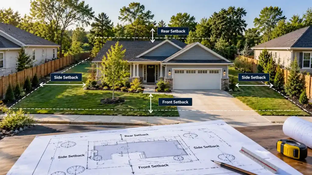
Property lines and setbacks are among the most important elements of residential permit drawings. A setback establishes the required distance between a structure and a designated property boundary or other regulated feature.
Understanding Front, Rear, and Side Setbacks
Residential zoning regulations commonly establish separate setback requirements for front, rear, and side yards. The applicable distances depend on the zoning district, structure type, and local ordinances. A detached garage may have different placement restrictions from a primary residence or attached addition.
Avoiding Measurement Errors
Measurements should be taken from the reference points required by the local jurisdiction. Depending on the regulation, reviewers may consider exterior walls, projections, foundations, or other defined building features. We recommend confirming these measurement rules before finalizing the proposed layout.
Our article on property setbacks on site plans provides additional guidance about setback documentation.
What Scale and Dimensions Should a Residential Site Plan Use?
A site plan must be readable and accurately proportioned. The drawing scale allows reviewers to interpret distances and understand the relationship between property features.
Choosing an Appropriate Drawing Scale
Common architectural scales include one inch representing ten, twenty, or thirty feet, although local requirements may specify a different scale. The selected scale should allow the entire property and relevant improvements to fit clearly on the drawing.
Avoid reducing a large property drawing until labels and measurements become difficult to read.
Showing Accurate Dimensions
Important dimensions typically include lot boundaries, building footprints, setbacks, and the location of proposed construction. Where required, the drawing should also identify distances between existing and proposed structures.
We prioritize consistent measurements because conflicting dimensions can make an otherwise complete drawing difficult to review.
Do Residential Site Plans Need Utilities and Drainage Details?
Utilities and drainage can affect construction feasibility and permit approval. The amount of information required depends on the proposed work and local review standards.
Utility Locations and Easements
Water, sewer, electrical, and other utility connections may need to appear on the drawing when they affect the project. Recorded utility easements can also restrict where structures may be placed.
Before selecting a final construction location, homeowners should review available utility records and identify relevant restrictions.
Drainage and Grading Information
Construction can change how stormwater moves across a property. Home additions, patios, driveways, and accessory structures may introduce new impervious surfaces or alter existing ground elevations.
Some jurisdictions require drainage arrows, elevation information, or grading plans. Complex conditions may require engineering documentation beyond a standard site plan.
Can You Prepare a Residential Site Plan Without a Survey?
Some building departments accept drawings prepared from existing surveys, recorded documents, parcel information, and reliable property measurements. However, publicly available mapping information does not always establish precise legal boundaries.
When Existing Records May Be Sufficient
For straightforward projects with reliable documentation, available property records may provide enough information to prepare a site plan that satisfies local submission standards. The building department determines whether that information is acceptable.
When a Professional Survey Is Necessary
A survey may be required when boundary locations are uncertain, structures are proposed close to property lines, or local regulations specifically require certified measurements. Disputed boundaries, unusual lot shapes, and conflicting property records can also justify professional surveying.
Our site plan without a survey guide explains the limitations homeowners should understand before relying on existing records.
Common Residential Site Plan Mistakes to Avoid
Incomplete drawings can delay permit review even when the proposed construction is otherwise straightforward. We advise homeowners to review their plans carefully before submission. Common documentation problems include:
- Missing property dimensions or unclear boundary lines.
- Incorrect setback measurements.
- Existing structures omitted from the drawing.
- Proposed construction without complete dimensions.
- Unidentified easements or restricted areas.
- Missing drawing scale or north arrow.
- Conflicting measurements between submitted documents.
- Drawings that do not reflect the latest project design.
These errors can result in clarification requests, drawing revisions, or additional documentation requirements. Our guide to site plan rejection reasons explains common correction issues and practical ways to address them.
How to Prepare Your Site Plan Before Applying for a Permit
Residential site plan requirements vary by jurisdiction, so confirm the applicable submission checklist before drafting. This helps identify whether your project needs additional survey information, zoning documentation, or drainage details.
Step 1: Confirm Local Permit Requirements
Contact the appropriate city or county building department and request the current site plan checklist. Ask whether the project requires a survey, zoning review, drainage information, or other supporting documents.
Step 2: Collect Property Documents
Gather available surveys, recorded parcel documents, previous permit drawings, and relevant property measurements. Include information about existing buildings and any recorded restrictions affecting construction.
Step 3: Finalize the Proposed Layout
Confirm the dimensions and intended location of the proposed improvement with your contractor or designer. Avoid submitting preliminary measurements that are likely to change during construction planning.
Step 4: Review the Completed Drawing
Compare the drawing against the permit checklist and available property records. Check setbacks, dimensions, labels, and existing improvements for consistency. For homeowners who need drafting assistance, our residential site plan services provide support in preparing organized property drawings.
Why Choose City Permit Plans?
We help homeowners prepare clear residential site drawings with attention to property information, project scope, and applicable submission requirements.
- Property focused preparation: We organize available boundary information, existing structures, and proposed improvements into readable drawings.
- Permit documentation awareness: We consider the relevant local checklist when preparing project information.
- Nationwide service: We support residential projects throughout all 50 US states.
- Clear communication: We help identify missing information and explain when additional professional documentation may be necessary.
- Convenient online process: Homeowners can share project details and coordinate their drafting needs remotely.
If you are preparing for a residential construction project, request a site plan quote to discuss your property and drawing requirements.
Conclusion
Meeting residential site plan requirements begins with accurate boundaries, clearly labeled structures, correct setbacks, and complete dimensions. Review your drawing against local permit standards before submission to reduce avoidable corrections and prepare a more complete application.
Frequently Asked Questions
What Are the Basic Residential Site Plan Requirements?
A typical residential drawing includes property boundaries, lot dimensions, existing buildings, proposed improvements, setback distances, drawing scale, and a north arrow. Additional information depends on local regulations and project scope.
Can Homeowners Draw Their Own Residential Site Plans?
Some jurisdictions accept homeowner prepared drawings when they meet the required standards. However, unclear measurements, inaccurate property information, or missing features can result in corrections.
Is a Residential Site Plan the Same as a Property Survey?
No. A site plan illustrates existing and proposed property improvements. A professional land survey establishes boundary information and other surveyed conditions using recognized surveying methods.
How Long Does It Take to Prepare a Residential Site Plan?
Preparation time depends on property complexity, available records, and the level of detail required. Straightforward projects may take a few business days, while more complex properties can require additional research or documentation.
Does Every Home Improvement Project Require a Site Plan?
No. Permit requirements vary by jurisdiction and project type. Some minor improvements may be exempt, while additions, accessory structures, and other exterior construction commonly require site drawings.