
Survey vs site plan is an important distinction to understand when preparing documents for a building permit. If your permit checklist asks for a site plan, plot plan, survey, boundary survey, or a site plan based on a survey, it is easy to assume these documents are interchangeable. They are not, A site plan generally shows how existing and proposed improvements fit on a property for planning or permit review. A property survey establishes or verifies boundary and other field information within the professional scope of a licensed land surveyor.
For some projects, existing property records provide enough information to prepare the site plan required by the permit office. For others, the jurisdiction may require a current survey or licensed surveyor involvement before it will accept the drawing. The deciding factor is not simply whether you are building a deck, fence, pool, shed, addition, or ADU. It is what your reviewing jurisdiction requires and how much verified property information your project depends on.
This guide explains the difference between a site plan and survey, when they can work together, and how to determine whether you actually need a property survey before applying for a permit.
Survey vs Site Plan: The Simple Difference
The easiest way to understand the difference is to look at the question each document answers.
A property survey helps establish:
Where are the property’s legally relevant boundaries and field conditions?
A site plan helps explain:
Where are the existing and proposed improvements located in relation to the property and applicable site requirements?
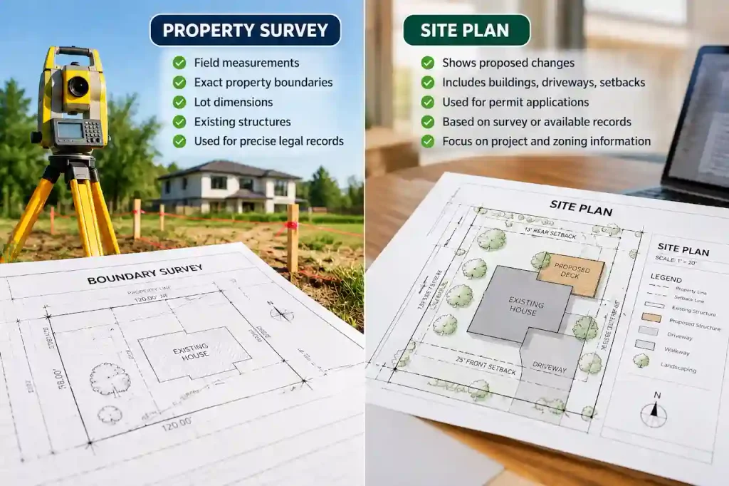
That distinction is important. A survey can provide highly reliable base information for a site plan, but a survey by itself may not show everything required for your proposed permit. Likewise, a drafted site plan may show property lines based on available records, but that does not turn the drawing into a licensed boundary survey.
What Is a Site Plan?
A site plan is a scaled overhead drawing showing the layout of a property and the improvements relevant to a proposed project. Depending on the permit, it may show the property lines and lot dimensions, existing house or commercial building, proposed construction, setbacks, driveways, easements, utilities, parking, access, and other site conditions.
For example, someone applying for a deck permit may need a site plan showing the house, proposed deck dimensions, stairs, lot lines, setbacks, and relevant easements.
For a pool permit, the drawing may instead focus on the proposed pool, property boundaries, nearby structures, setbacks, equipment, access, barriers, and other jurisdiction-required information. The site plan’s purpose is primarily to communicate the project clearly enough for the reviewing authority to evaluate its placement on the property.
What Is a Property Survey?
A property survey is prepared within the professional scope of a licensed land surveyor. Unlike a basic permit drawing assembled from available records, surveying can involve record research, field measurements, monuments, boundary evidence, specialized equipment, and professional analysis. Different types of surveys serve different purposes.
A boundary survey focuses on property boundaries. A topographic survey records elevations and physical features. Other survey products may document improvements, construction conditions, easements, or other information. That is why simply saying “I need a survey” may not be specific enough. If the permit department requests one, determine exactly what type of survey information it needs.
Site Plan vs Property Survey: Key Differences
Understanding survey vs site plan requirements makes it easier to determine which document your permit office expects.
| Site Plan | Property Survey | |
|---|---|---|
| Primary purpose | Shows property layout and proposed work for review | Establishes or verifies survey information |
| Common permit use | Shows where proposed construction will be located | Provides verified boundary, elevation, or other survey data when required |
| Licensed surveyor always required? | Not necessarily; depends on jurisdiction and scope | Surveying must be performed according to applicable licensing requirements |
| Shows proposed work? | Usually | Not necessarily |
| Can show setbacks? | Yes | May provide the boundary information used to calculate them |
| Legal boundary determination? | No, not simply because property lines are drawn | Can establish professional boundary opinions within the survey scope |
| Can one replace the other? | Not automatically | Not automatically |
The two documents should therefore be viewed as related tools rather than competing alternatives. Sometimes you need only a permit site plan. Sometimes you need survey information first. Sometimes you need both.
Can You Create a Site Plan Without a New Survey?
In some situations, yes, A site plan can potentially be prepared from available property information when the jurisdiction does not require a new survey and the available records are adequate for the requested scope. Useful source information may include an existing survey, recorded plat, assessor or parcel information, GIS records, previous approved plans, deeds, aerial imagery, field measurements, and other available property records.

However, these sources do not all have the same accuracy or legal significance. County GIS data, for example, can be extremely useful for understanding a parcel, but GIS parcel lines should not automatically be treated as surveyed property boundaries. Satellite or aerial imagery has similar limitations. These tools can support drafting, but they cannot independently resolve a disputed property line or provide a professional surveyor’s boundary determination.
When Does a Permit Office Require a Survey?
There is no nationwide rule stating that every permit requires or does not require a property survey. Local requirements control. A jurisdiction may require surveyor involvement because of the type of project, location of proposed construction, quality of available property information, topography, legal boundaries, or other site conditions. Here are some of the situations where a survey becomes more likely.
The Permit Checklist Specifically Requires One
This is the clearest situation. If the jurisdiction requires a boundary survey, topographic survey, surveyor-prepared site plan, certified plot plan, or another specifically defined survey product, a generic drafted site plan should not be substituted without confirmation. Read the terminology carefully. Some building departments use “plot plan” or “site plan” broadly, while others define exactly who can prepare the drawing and what source information must be used.
Proposed Construction Is Very Close to a Property Line
Setbacks are measured from legally relevant property boundaries. If a proposed garage, addition, ADU, deck, pool, shed, or other improvement is close to the minimum allowed setback, small boundary uncertainties can become important. Suppose zoning requires a five-foot setback and your available records suggest the proposed structure is approximately five feet from the property line. That leaves very little room for uncertainty.
The permit authority or project professional may require more reliable boundary verification before construction proceeds.
Property Corners or Boundaries Are Unclear
A fence, hedge, driveway, wall, or line shown on an online map does not necessarily establish the legal boundary. If the property’s corners cannot be identified reliably, records conflict, or the apparent occupation line differs from available parcel information, a licensed surveyor may be needed. This is particularly important when construction depends on the precise boundary location.
There Is a Boundary or Encroachment Dispute
A drafting service should not attempt to resolve a legal boundary dispute. If neighbors disagree about a property line or an existing fence, driveway, wall, building, or other improvement may cross a boundary, the issue should be addressed by the appropriate licensed professional. A site plan can illustrate information supplied to the drafter, but it cannot independently settle a disputed boundary.
Elevations or Topography Matter
Some projects depend on more than horizontal property dimensions. Grading, drainage, retaining walls, hillside construction, flood conditions, driveway slopes, development on uneven terrain, and certain additions may require accurate elevation information. A topographic survey may be necessary when the design depends on existing grades or elevations. This is different from a basic boundary survey, which is why the permit office’s exact request matters.
The Project Involves Subdivision or Other Land Actions
Projects involving subdivision, lot-line adjustments, parcel creation, easement work, or similar legal land matters generally require much more precise property information than a straightforward residential permit site plan. These are not situations where approximate parcel mapping should be used as a substitute for professional surveying.
The Jurisdiction Requires Licensed Professional Certification
Some municipalities specify conditions under which a licensed surveyor, engineer, architect, or another qualified professional must prepare or certify parts of the submission. For example, the City of San Diego’s current site-plan guidance includes a dedicated section explaining when a surveyor’s signature and stamp are required and provides options involving boundary and topographic survey information. This demonstrates why national statements such as “a survey is never needed for a deck” or “all additions require surveys” are unreliable. The answer depends on the applicable rules and actual site conditions.
When Might a Site Plan Be Enough?
If the permit authority accepts a site plan based on available property records and the project does not depend on professionally verified boundary or elevation information, ordering a new survey may not be necessary. This can occur with relatively straightforward projects where reliable property documentation already exists and the proposed improvement has comfortable clearance from property boundaries and other constraints.
Do not determine that a survey is unnecessary solely because another homeowner in another city obtained a similar permit without one. Two apparently identical deck projects can have different requirements because the lots, setbacks, easements, zoning districts, or local submission rules differ.
Do You Need a Survey for a Fence Permit?
Not automatically, A permit office may accept a site plan showing the proposed fence location based on reliable existing property information. However, fences create an obvious boundary concern because they are often constructed on or near property lines.
If the boundary location is uncertain, disputed, or critical to placement, obtaining professional boundary verification may be appropriate even if the permit checklist itself is relatively simple. The later construction location matters just as much as the permit drawing.
Do You Need a Survey for a Deck Permit?
A site plan for a deck commonly shows the house, proposed deck footprint, stairs, property boundaries, setbacks, easements, and relevant dimensions. If the deck is comfortably inside required setbacks and acceptable property information already exists, the jurisdiction may not require a new survey. If the deck approaches a setback, easement, or uncertain boundary, more reliable survey information may be necessary.
Do You Need a Survey for a Pool Permit?
Pool projects can make property accuracy especially important because the permit review may consider setbacks, easements, structures, equipment, barriers, utilities, septic systems, drainage, and other site constraints. Whether those conditions require a new survey depends on the property and jurisdiction. An existing reliable survey may also be useful as the base for preparing the proposed pool site plan.
Do You Need a Survey for an Addition or ADU?
Additions and ADUs can create more complex zoning questions because the proposed building footprint affects setbacks, lot coverage, building separation, access, utilities, and potentially other development standards.
A survey may therefore become more important when the proposed footprint is close to a boundary or when existing property information is uncertain. But there is still no universal rule that every addition or ADU automatically requires a new survey. Check the jurisdiction’s current submittal requirements before ordering one.
Can an Existing Survey Be Used for a New Permit?
If you already have a survey, provide it when preparing the site plan. An existing survey can offer valuable base information about property lines, lot dimensions, easements, and existing improvements. However, its age matters less than whether it still accurately represents the conditions relevant to the project.
Since the survey was prepared, the property may have gained an addition, shed, pool, driveway, fence, easement, lot-line change, or other improvement. The permit office may also have rules about how current the information must be. Instead of assuming an old survey is unusable or automatically acceptable compare it with current conditions and the jurisdiction’s requirements.
Can County GIS Replace a Property Survey?
No, not when a licensed survey is actually required. GIS systems are valuable research tools. They can provide parcel mapping, assessor information, aerial imagery, zoning layers, flood information, and other useful records. But GIS parcel lines are generally mapping information rather than a substitute for professional boundary determination. This distinction becomes critical near property lines.
If a site plan is prepared using GIS information, the drawing should not be represented as a licensed boundary survey. When exact boundary verification is required, a licensed land surveyor is the appropriate professional.
Can a Site Plan Replace a Survey?
This question is slightly misleading because the documents have different purposes. If your permit office requires only a site plan, then you may not need a new survey in the first place. But if the jurisdiction specifically requires a survey or your project depends on professional boundary verification, creating a more detailed site plan does not transform it into a survey. The better question is:
What information does my permit office require, and does that information need to be professionally surveyed?
That question usually makes the decision much clearer.
How a Survey and Site Plan Work Together
For many projects, the strongest workflow is not “site plan versus survey.” It is survey plus site plan. The survey can provide verified base information. The site plan then uses the relevant information to show the proposed project.
For example, a survey may establish the property boundary and easements. The permit site plan can then show the proposed addition, its dimensions, distances to those boundaries, access, and other information required for review.
The survey establishes important existing information. The site plan communicates the proposed project.
How to Determine What Your Permit Office Actually Wants
Before paying for a new survey, check the current requirements for your exact jurisdiction and project. Start with the building, planning, zoning, or development-services department responsible for the property. Look for the permit application and drawing checklist for your project type. Then check the terminology carefully.
Does it ask for a site plan, plot plan, boundary survey, topographic survey, certified site plan, or a plan prepared by a licensed surveyor?
If the requirement is unclear, ask the department whether an existing survey or a site plan prepared from available property records will satisfy the application. This small step can prevent you from ordering the wrong document.
What to Send Before Your Site Plan Is Drafted
If the jurisdiction confirms that a drafted site plan is acceptable, provide the best property information you already have. That may include an existing survey or plat, property address, parcel number, previous approved drawings, permit checklist, correction notice, photos, measurements, project sketch, and a clear description of the proposed work. The goal is not to avoid surveying at all costs. The goal is to use the appropriate level of property information for the actual permit requirement.
Site Plan or Survey? Use This Decision Rule
A simple way to approach the decision is:
- If the permit office needs to understand where your proposed project will sit on the property, you likely need a site plan.
- If the project requires professionally established boundaries, elevations, or other surveyed field information, you may also need a survey.
And if the permit office explicitly requires both, submit both. This is more reliable than choosing based only on project type, cost, or what another jurisdiction accepted.
Get a Site Plan Using Your Available Property Information
If your permit office allows a site plan without requiring a new survey, City Permit Plans can prepare the permit drawing using the available property information appropriate to the project scope. Provide your property address, project details, any existing survey or plat, available measurements, photos, and the jurisdiction’s permit checklist. The available information can then be reviewed before drafting begins.
If the project requires licensed surveying, boundary verification, topographic information, engineering, or another professional service beyond the drafting scope, that requirement should be identified rather than representing a drafted site plan as a substitute.
Learn About Site Plans Without a Survey
Frequently Asked Questions
Is a site plan the same as a property survey?
No. A site plan generally shows existing and proposed improvements for planning or permit review. A property survey is prepared within the professional scope of a licensed land surveyor and can establish or verify boundary and other survey information.
Do I always need a survey before getting a site plan?
No. Some jurisdictions accept site plans prepared from available property information. Others require survey information depending on the project and site conditions. Check the requirements for your permit before ordering a new survey.
Can I use an old property survey for a building permit?
Possibly. An existing survey can provide useful base information, but it should be checked against current site conditions and the permit office’s requirements.
Does a site plan show property lines?
Site plans commonly show property lines, but drawing a property line on a site plan does not make the document a licensed boundary survey.
Who determines whether my project needs a survey?
The applicable jurisdiction determines its permit submission requirements. A project architect, engineer, surveyor, or other professional may also determine that verified survey information is necessary for design or construction.
What if I am not sure whether my permit checklist requires a survey?
Ask the reviewing department whether it will accept a site plan prepared from your existing property information or whether it specifically requires a current survey or licensed surveyor’s certification.