California Site Plan Permits: What Homeowners Should Prepare
Planning a residential construction project in California often begins long before excavation, demolition, or building work starts.
Whether you are constructing an accessory dwelling unit, expanding your home, installing a swimming pool, building a detached garage, adding a deck, or replacing a fence, the local building or planning department may require a site plan as part of the permit application.
A site plan gives officials an overhead view of the complete property. It shows existing buildings, property boundaries, proposed construction, setbacks, easements, access routes, utilities, drainage conditions, and other features that may affect the project.
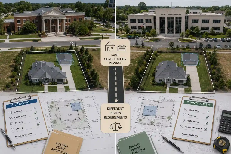
California follows statewide building standards, but permit procedures and development rules are administered locally. Requirements can therefore differ between Los Angeles, San Diego, Sacramento, San Jose, and smaller California municipalities.
Understanding what local departments commonly review can help homeowners prepare clearer documents and avoid preventable correction requests.
Table of Contents
- What Is a California Residential Site Plan?
- Why California Cities Place Strong Emphasis on Site Plans
- Who Reviews Residential Permits in California?
- Property Boundaries and Lot Dimensions
- Existing Buildings and Property Improvements
- Proposed Construction
- California Setback Requirements
- Easements and Restricted Areas
- Accessory Dwelling Unit Site Plans
- Home Additions and Expansions
- Detached Garages and Accessory Structures
- Swimming Pools and Spas
- Decks, Patios, and Pergolas
- Fence and Gate Projects
- Los Angeles Site Plan Considerations
- Driveways, Parking, and Access
- Lot Coverage and Floor-Area Limits
- Utilities and Site Services
- Drainage, Grading, and Sloped Properties
- Fire Access and Wildfire Conditions
- Coastal and Environmentally Sensitive Properties
- Homeowners Association and Private Requirements
- Common Reasons California Site Plans Receive Corrections
- Property Information Does Not Match
- Existing Structures Are Missing
- Proposed Construction Is Unclear
- Setback Measurements Are Missing
- Easements Are Not Identified
- Access and Parking Are Not Addressed
- Plans Show Different Dimensions
- Local Requirements Were Not Verified
- Grading or Drainage Conditions Were Ignored
- How to Prepare Before Submission
- What Happens During Permit Review?
- Can Homeowners Prepare Their Own Site Plans?
- Final Thoughts
- Get a Site Plan Ready for California Permit Offices
- Frequently Asked Questions
What Is a California Residential Site Plan?
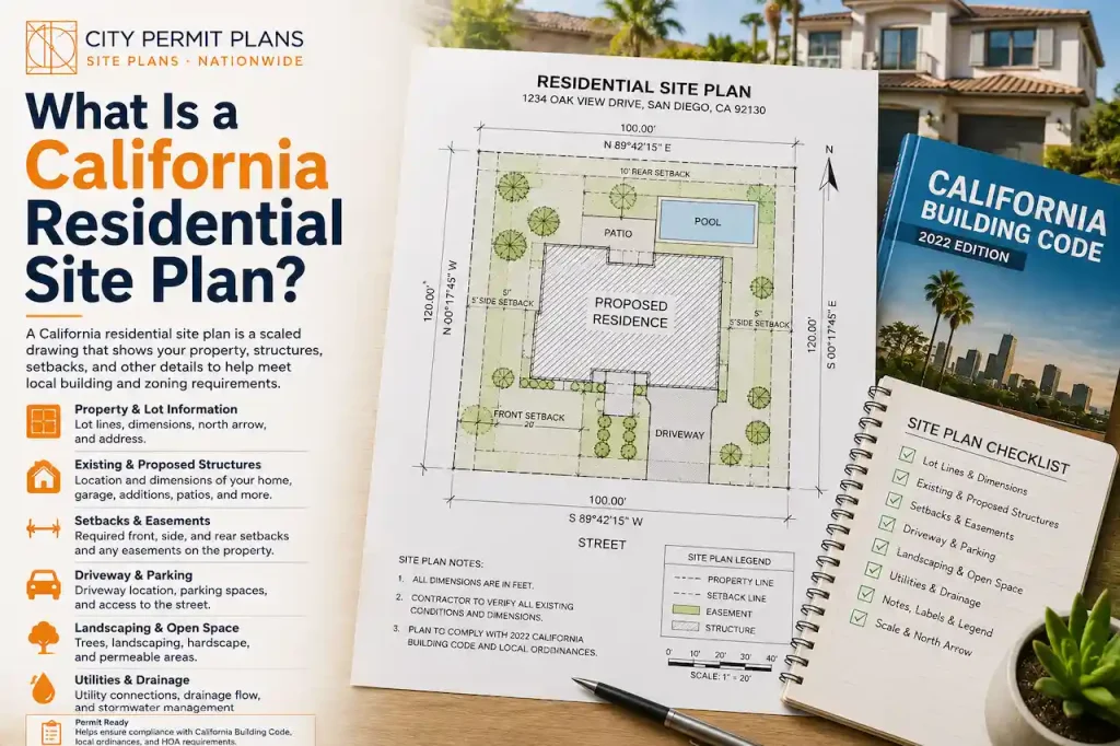
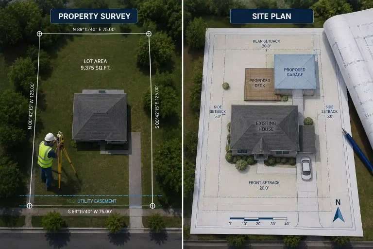
A California residential site plan is a scaled drawing showing the existing property and the proposed construction from an overhead perspective.
It explains where the project will be located and how it relates to the surrounding property.
A typical site plan may include:
- Property boundaries
- Lot dimensions
- Existing residence
- Garages and accessory structures
- Proposed construction
- Front, side, and rear setbacks
- Driveways
- Parking areas
- Walkways
- Patios and decks
- Swimming pools
- Fences and gates
- Utility easements
- Drainage features
- Retaining walls
- Septic systems and wells
- North arrow
- Drawing scale
- Property address
- Parcel information
The site plan is different from architectural and structural drawings.
Architectural plans show room layouts, doors, windows, elevations, and other building details. Structural drawings explain how the proposed improvement will be supported and constructed. The site plan shows how the entire project fits within the land.
Homeowners planning projects throughout the state can review California site plan services to understand the property-level information commonly included in permit-focused drawings.
Why California Cities Place Strong Emphasis on Site Plans
California properties vary significantly in size, density, slope, environmental conditions, neighborhood design, and available building space.
A suburban property may have different development constraints from:
- A dense urban lot
- A hillside property
- A coastal parcel
- A corner lot
- A narrow lot
- A property in a wildfire area
- A property with an ADU
- A lot containing multiple accessory structures
Before evaluating detailed construction documents, officials need to understand the existing site and the proposed project location.
The site plan helps reviewers determine whether the project:
- Remains within the property boundaries
- Meets required setbacks
- Avoids restricted easements
- Complies with lot coverage limits
- Maintains access
- Coordinates with utilities
- Avoids drainage conflicts
- Fits around existing structures
- Satisfies local development standards
A project may be structurally acceptable but still require revisions because its proposed location conflicts with zoning or property restrictions.
Who Reviews Residential Permits in California?
The exact review process depends on the city, county, and project type.
A California residential permit application may involve:
- Building department
- Planning department
- Zoning department
- Public works department
- Fire department
- Utility provider
- Environmental department
- Health department
- Floodplain administrator
- Homeowners association
Some projects require review from several departments before a building permit can be issued.
For example, an ADU project may involve planning, building, utilities, fire access, energy compliance, and drainage review.
A hillside addition may require structural, grading, drainage, geotechnical, and fire-department documentation.
Homeowners should identify the correct permitting authority before preparing the application.
Property Boundaries and Lot Dimensions
Property boundaries establish the legal limits of the parcel and provide the reference points for setbacks, easements, lot coverage, and project placement.
Boundary information may come from:
- An existing boundary survey
- A recorded subdivision map
- Previous approved plans
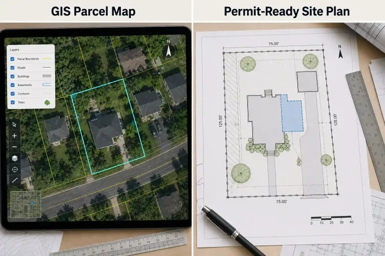
- County parcel information
- Recorded deed documents
- Owner-provided records
- A licensed surveyor
A fence, wall, hedge, landscaping edge, or neighboring driveway should not automatically be treated as the legal property line.
Online parcel maps and aerial images can support preliminary planning, but they may not provide sufficient accuracy for construction close to a boundary.
A current survey may be required when:
- The project is near a property line
- The lot is irregular
- Easements are unclear
- Property records conflict
- Elevation information is required
- The jurisdiction specifically requests one
A drafted site plan should not be described as a licensed boundary survey.
Existing Buildings and Property Improvements
Permit reviewers need to understand the existing property before evaluating the proposed work.
The site plan may need to identify:
- Main residence
- Attached garage
- Detached garage
- Sheds
- Accessory buildings
- Existing ADUs
- Patios
- Decks
- Swimming pools
- Driveways
- Walkways
- Fences
- Retaining walls
- Utility equipment
- Septic systems
- Wells
These features affect available building space, setbacks, access, utilities, drainage, fire separation, and lot coverage.
Leaving out permanent property improvements can make the proposed project appear to have more available space than it actually does.
Proposed Construction
The proposed work should be clearly distinguished from existing conditions.
The drawing may identify:
- Project type
- Proposed footprint
- Overall dimensions
- Building orientation
- Attached or detached condition
- Stairs and landings
- Access points
- Demolition areas
- Relocated structures
- New paved areas
Different line weights, shading, labels, or notes can help reviewers understand the project quickly.
The dimensions shown on the site plan should remain consistent with the architectural drawings, structural plans, contractor documents, and permit application.
California Setback Requirements
Setbacks establish the minimum distance between proposed construction and property boundaries, streets, buildings, or other regulated features.
There is no single setback standard that applies to every California property.
Requirements may depend on:
- City or county
- Zoning district
- Lot size
- Property shape
- Corner-lot status
- Project type
- Structure height
- Existing buildings
- Easements
- Fire-separation requirements
- Coastal or environmental restrictions
Setbacks may be required from:
- Front property line
- Rear property line
- Side property lines
- Street-side property line
- Existing residence
- Accessory structures
- Swimming pools
- Easements
- Septic systems
- Wells
- Waterways
- Protected areas
The site plan should clearly label the proposed distances and identify the measurement points.
A deck, pool, ADU, fence, garage, and home addition may each follow different placement rules.
Easements and Restricted Areas
Recorded easements may limit where permanent construction can occur.
Common examples include:
- Utility easements
- Drainage easements
- Sewer easements
- Access easements
- Shared driveway easements
- Conservation easements
- Public rights-of-way
An easement may give another party the right to access, install, maintain, or replace infrastructure across part of the property.
Construction inside an easement may be prohibited or may require written approval.
An empty backyard area should not automatically be considered buildable until available surveys, plats, title documents, and property records have been reviewed.
Accessory Dwelling Unit Site Plans
Accessory dwelling units are among the most common California projects requiring detailed property-level planning.
An ADU site plan may need to show:
- Existing residence
- Proposed ADU
- ADU dimensions
- Building setbacks
- Distance between structures
- Driveway
- Parking
- Walkways
- Utility connections
- Easements
- Drainage
- Fire access
- Septic systems
- Existing accessory buildings
The permit office may also evaluate:
- Unit size
- Building height
- Lot coverage
- Fire separation
- Utility capacity
- Entrance location
- Privacy
- Construction access
A detached ADU may follow different requirements from a garage conversion, internal ADU, attached addition, or unit constructed above a garage.
Home Additions and Expansions
Room additions increase the footprint of the primary residence and may affect several development standards.
The site plan may need to identify:
- Existing residence
- Proposed addition
- Addition dimensions
- Property-line setbacks
- Building separation
- Lot coverage
- Driveway access
- Utility conflicts
- Drainage changes
- Existing patios and pools
The proposed footprint should be shown clearly in relation to the existing building.
A second-story addition may not increase the ground-level footprint, but it can still involve height, privacy, structural, fire, and neighborhood-design review.
Detached Garages and Accessory Structures
Detached garages, workshops, sheds, carports, studios, and other accessory structures create new permanent improvements on the property.
Officials may review:
- Structure location
- Side and rear setbacks
- Building height
- Distance from the residence
- Driveway access
- Utility easements
- Fire separation
- Lot coverage
- Drainage
- Septic-system conflicts
Accessory structures may follow different placement rules from the primary residence.
A garage with plumbing or living space may require additional review beyond a standard storage structure.
Swimming Pools and Spas
A pool permit package may include property-level, structural, electrical, plumbing, equipment, and safety documentation.
The site plan may show:
- Pool location
- Pool dimensions
- Distance from property lines
- Distance from buildings
- Pool deck
- Equipment pad
- Pumps and heaters
- Fence or barrier
- Gate locations
- Utilities
- Easements
- Drainage
- Existing structures
The permit office may also evaluate electrical clearances, pool barriers, access, grading, and equipment placement.
The site plan should match the pool contractor’s layout and supporting documents.
Decks, Patios, and Pergolas
Decks, patios, pergolas, and covered outdoor structures may affect setbacks, lot coverage, drainage, access, and building attachment.
The site plan may need to show:
- Deck or patio footprint
- Overall dimensions
- Stairs
- Landings
- Property-line setbacks
- Distance from the house
- Covered and uncovered areas
- Existing doors
- Pools
- Fences
- Utility locations
A covered patio may follow different requirements from an uncovered deck because the roof can affect structural loads, setbacks, drainage, and coverage calculations.
Fence and Gate Projects
Fence projects may require property-level documentation when location, height, visibility, access, or easements need to be reviewed.
The site plan may identify:
- Complete fence alignment
- Fence height
- Fence material
- Gate locations
- Property boundaries
- Streets
- Sidewalks
- Driveways
- Easements
- Corner-lot visibility
- Pool barriers
An existing fence should not automatically be treated as the legal property line.
Front-yard and corner-lot fences may be subject to stricter height or visibility requirements than rear-yard fences.
Los Angeles Site Plan Considerations
Los Angeles-area projects may involve local zoning, property-layout, hillside, fire-access, parking, drainage, and neighborhood-specific requirements.
The required information depends on the project and property.
A Los Angeles site plan may need to coordinate:
- Existing building footprint
- Proposed construction
- Property boundaries
- Setbacks
- Parking
- Driveway access
- Hillside conditions
- Retaining walls
- Utilities
- Drainage
- Fire access
- Accessory structures
Homeowners planning work in the area can review Los Angeles, California site plan services for location-specific property drawing support.
The official city or county checklist should still control the final permit submission.
Driveways, Parking, and Access
A residential site plan may need to show how vehicles, residents, contractors, inspectors, and emergency personnel will access the property.
Relevant information may include:
- Existing driveway
- Proposed driveway
- Parking spaces
- Walkways
- Gates
- Alleys
- Construction access
- Emergency access
- Curb cuts
Access is especially important for ADUs, garages, additions, pools, and projects located behind the main residence.
A project may satisfy setbacks but remain impractical if construction equipment cannot reach the site.
Lot Coverage and Floor-Area Limits
California municipalities may regulate the amount of property covered by buildings and other improvements.
Calculations may involve:
- Existing building footprint
- Proposed building footprint
- Total lot coverage
- Floor-area ratio
- Impervious surface
- Open space
- Patio area
- Driveway area
The calculation method depends on the jurisdiction and zoning district.
A property may appear to have sufficient open space while already approaching an allowable coverage or floor-area limit.
Utilities and Site Services
Proposed construction may need to coordinate with existing and future utility systems.
The site plan may identify:
- Water service
- Sewer connection
- Septic system
- Electrical service
- Gas service
- Utility meters
- Transformers
- Communication lines
- Stormwater infrastructure
- Mechanical equipment
Detailed utility drawings may be prepared separately.
However, the site plan should provide enough property-level context for reviewers to understand where services are located and how the proposed project may affect them.
Drainage, Grading, and Sloped Properties
New construction can change the way water moves across a property.
Permit reviewers may consider:
- Existing drainage direction
- Proposed runoff
- Roof drainage
- Low areas
- Drainage swales
- Retaining walls
- Driveway slopes
- Neighboring properties
- Flood conditions
- Increased impervious surface
Sloped and hillside properties may require additional information such as:
- Topographic survey
- Existing contours
- Proposed grading
- Retaining-wall details
- Drainage design
- Geotechnical reports
- Erosion-control measures
A basic site plan may not replace specialized grading, drainage, structural, or geotechnical documents.
Fire Access and Wildfire Conditions
Some California properties are located in areas where fire access, defensible space, or wildfire-related construction requirements may affect the project.
Reviewers may consider:
- Emergency vehicle access
- Driveway width
- Turnaround space
- Building separation
- Vegetation clearance
- Water supply
- Fire-resistant construction
- Address visibility
The required documents vary by jurisdiction and project.
Fire-department review may occur separately from ordinary planning and building review.
Coastal and Environmentally Sensitive Properties
Properties near the coast, wetlands, waterways, protected habitats, or other environmentally sensitive areas may require additional review.
Potential considerations include:
- Coastal development requirements
- Environmental buffers
- Wetlands
- Erosion
- Flood hazards
- Protected trees
- Drainage
- Shoreline setbacks
Additional local, state, or environmental authorities may be involved.
Homeowners should identify these conditions before finalizing the project design.
Homeowners Association and Private Requirements
Municipal approval does not automatically confirm compliance with homeowners association rules or private deed restrictions.
An HOA may regulate:
- Exterior appearance
- Materials
- Colours
- Building height
- Accessory structures
- Fences
- Parking
- Driveways
- Setbacks
- Landscaping
HOA approval does not replace a building permit, and a building permit does not replace HOA approval.
Both sets of requirements should be reviewed before construction begins.
Common Reasons California Site Plans Receive Corrections
Permit applications are often delayed because information is incomplete, inconsistent, or based on incorrect assumptions.
Property Information Does Not Match
The site plan, application, survey, architectural drawings, and contractor documents should contain consistent property and project information.
Existing Structures Are Missing
Leaving out garages, sheds, pools, decks, patios, retaining walls, or driveways can make the site review incomplete.
Proposed Construction Is Unclear
Reviewers should be able to identify the proposed project immediately.
Unclear line work, labels, or dimensions may result in correction requests.
Setback Measurements Are Missing
Officials cannot verify zoning compliance when required distances are not shown.
Easements Are Not Identified
A project may satisfy normal setbacks but still conflict with a utility, drainage, sewer, or access easement.
Access and Parking Are Not Addressed
ADUs, garages, additions, and other projects may require clearer vehicle, pedestrian, construction, or emergency access information.
Plans Show Different Dimensions
The site plan, floor plan, structural drawings, and permit application should describe the same project.
Local Requirements Were Not Verified
Using another California municipality’s checklist may result in missing forms, incorrect notes, or unsuitable drawing details.
Grading or Drainage Conditions Were Ignored
Projects involving slopes, retaining walls, increased roof area, paving, or major excavation may require additional drainage or grading information.
How to Prepare Before Submission
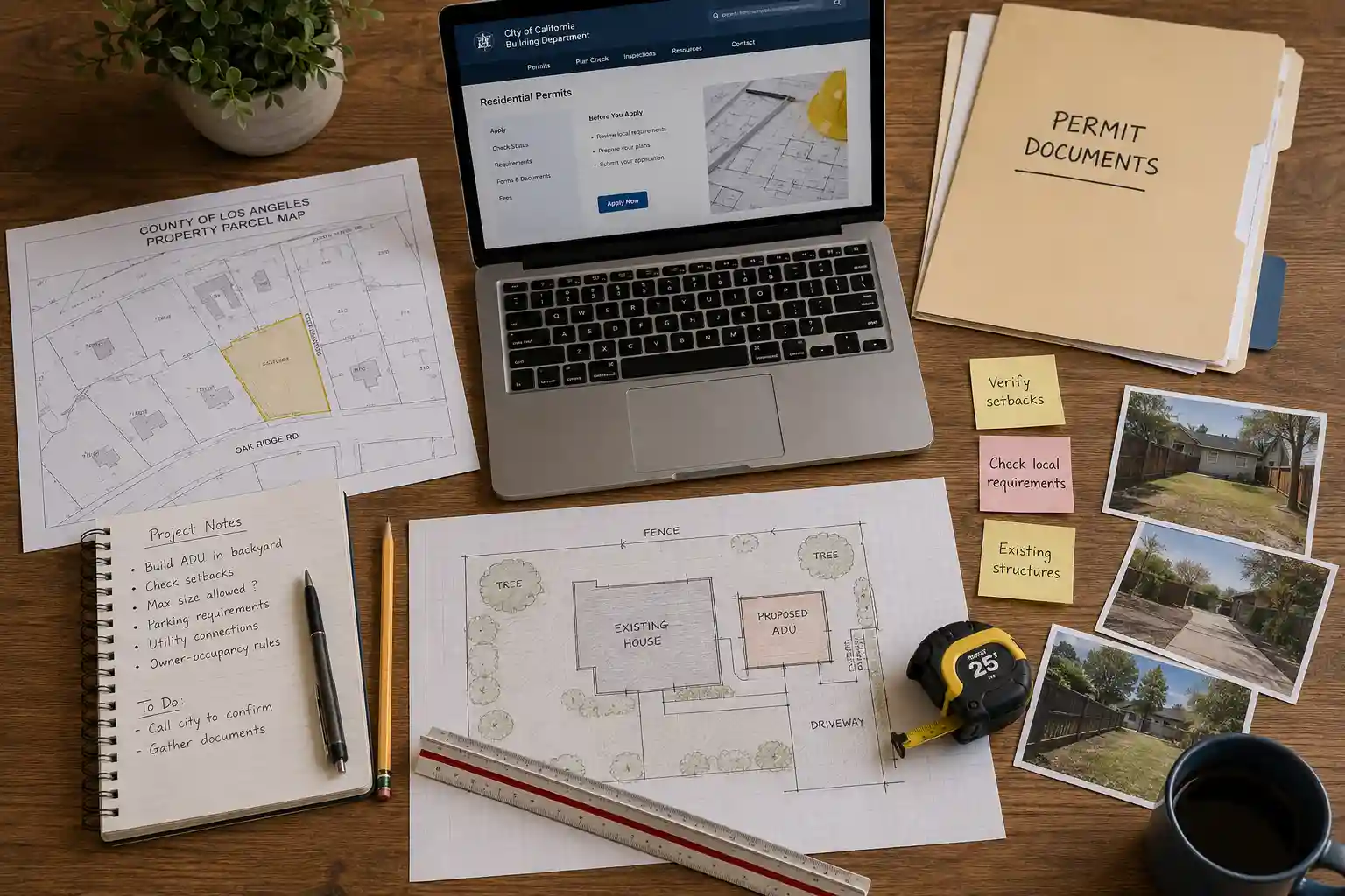
A more complete permit application begins with early planning.
Identify the Permit Authority
Confirm whether the property is reviewed by a city, county, planning department, building department, fire authority, health department, or another agency.
Review the Official Requirements
Obtain the latest:
- Permit application
- Drawing checklist
- Zoning requirements
- Submission instructions
- Required forms
- Supporting-document list
- Fee information
Gather Property Documents
Useful records may include:
- Existing survey
- Recorded parcel map
- County parcel information
- Previous site plan
- Easement documents
- Utility records
- Property photographs
Define the Complete Project
Confirm the proposed dimensions, location, height, access, use, materials, and related improvements.
Coordinate All Drawings
The site plan should match the architectural, structural, contractor, engineering, and application documents.
Review the Final Package
Before submitting, verify:
- Property address
- Project description
- Property boundaries
- Existing structures
- Proposed construction
- Setbacks
- Easements
- Access
- Utilities
- Drainage
- Drawing scale
- North arrow
- Required notes
A residential site plan service may help prepare the property-level drawing when the permit office requires a clear, scaled site layout.
What Happens During Permit Review?
After submission, the application may pass through several review stages.
These may include:
- Application intake
- Planning review
- Zoning review
- Building review
- Fire review
- Public works review
- Utility review
- Environmental review
- Health-department review
- Correction comments
- Resubmission
- Permit issuance
If revisions are required, officials may request:
- Additional dimensions
- Revised setbacks
- Survey information
- Easement clarification
- Access details
- Drainage information
- Grading documents
- Utility information
- Updated project placement
- Supporting construction drawings
Each correction should be handled by the appropriate person, such as the homeowner, contractor, drafter, architect, engineer, surveyor, or utility professional.
Can Homeowners Prepare Their Own Site Plans?
Some California jurisdictions accept homeowner-prepared site plans for straightforward residential projects.
A homeowner-prepared drawing may be accepted when:
- The property is simple
- Reliable boundary information is available
- The project is well within setbacks
- No complex easements are involved
- No grading design is required
- The permit authority accepts owner-prepared drawings
The plan must still be accurate, complete, scaled where required, and consistent with the official checklist.
Professional assistance may be useful when:
- The property is irregular
- The project is close to a boundary
- Easements cross the property
- The site is sloped
- Retaining walls are involved
- Drainage is complex
- Fire access must be coordinated
- The permit office has issued corrections
- A reliable scaled base drawing is unavailable
A property-level drafting service does not replace licensed surveying, architecture, engineering, grading design, or other professional services when those are required.
Final Thoughts
California site plan requirements vary according to the city, county, zoning district, project type, property layout, environmental conditions, and local submission procedures.
Permit reviewers may examine property boundaries, setbacks, existing improvements, easements, access, parking, lot coverage, utilities, drainage, grading, fire access, and the proposed construction.
Homeowners should identify the correct permitting authority and review the official local checklist before finalizing the project location.
A clear, accurate site plan helps explain the complete project to the permit office and should remain consistent with every other document included in the application.
Get a Site Plan Ready for California Permit Offices
From Title 24 zoning rules to local setback requirements, we prepare a professional, permit-ready site plan built for California building departments. Starting at $129, delivered in 24–48 hours.
✅ 98% first-time approval rate | ✅ Unlimited free revisions | ✅ Money-back guarantee
Get My Quote →Frequently Asked Questions
1. What is a California site plan permit?
A California site plan permit generally refers to the site plan documentation submitted with a building permit application to show existing property conditions and proposed construction for municipal review.
2. Do all California cities require the same site plan information?
No. While many jurisdictions request similar information, each California city or county may establish its own permit submission requirements and review procedures.
3. What projects commonly require a California site plan?
Site plans are frequently required for home additions, Accessory Dwelling Units (ADUs), detached garages, swimming pools, patios, pergolas, decks, fences, and many other residential improvements.
4. Why are accurate site plans important for California permits?
Accurate site plans help building departments evaluate project placement, setbacks, property layout, and compliance with local development standards, reducing the likelihood of permit revisions.
5. Can I prepare my own California site plan?
Some municipalities allow homeowners to prepare their own drawings. However, professionally prepared site plans often provide greater accuracy, clearer organization, and stronger support during permit review.
6. How can a professionally prepared site plan help my California permit application?
Professionally prepared drawings present property information in a clear, organized format that supports municipal review, improves documentation quality, and helps simplify the California site plan permit process.